Flood Mitigation Program
Flood Outreach Information – Activity 320
As a part of flood mitigation projects and our community rating system, the City of Austin will provide base flood map information, floodway data, information regarding known flooding problems, such as localized drainage or storm water problems and historical flooding information.
To determine if your property lies within a floodplain, check our floodplain maps at http://www.ci.austin.mn.us/public-works/flood-mitigation-program. FEMA maps are also available at the Planning and Zoning and Engineering City offices as well as some elevation certificates. We can also reference our base map to determine if your property is in the floodplain.
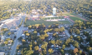
This notice has been mailed to all addresses located in or adjacent to the 100 year flood plain along the Cedar River, Turtle Creek, and Dobbins Creek. These streams are the major sources of flooding within the City of Austin. If you have received this notice, you are located in or very near the flood hazard area. The purpose of this notification is to inform you of the flood hazard associated with these streams and suggest possible action you can take to protect yourself.
FLOOD HAZARD AREA
Maps showing the limits of the 100 year flood plain are on file in the City Engineer’s Office located at 500 4th Avenue Northeast in Austin.
The 100 year flood plain is the area that has a 1% chance of being flooded in any given year, or on the average of once every 100 years. Put another way, the area has a 25% chance of being flooded over the life of a 30 year mortgage. Smaller floods have a greater chance of occurring in any year and can still create a significant flood hazard to people and property close to the channel. Also, larger floods can and do occur.
Austin is subject to dangerous flash flooding during or following heavy storms. Significant damaging floods have occurred in 1978 (twice), 1993, 2000, and 2004. The peak elevation of the September 2004 flood caused severely damaged foundation walls and basement floors, ruined furnaces, and other basement appliances were commonplace, along with 1st floor damage with many structures.
FLOOD WATCH AND WARNING SYSTEM
Austin has developed a flood watch and warning system for the flood plain area. Watches and warnings will be disseminated by local radio (1480 AM & 99.9 FM), TV (Channel 6), and by police vehicles equipped with high/low siren settings and public address systems.
A flood watch declaration means that flooding is possible within the watch area. A flood warning means that flooding is imminent. If a flood watch is declared, citizens in or near the flood plain should continue to monitor radio and/or TV announcements for changes in the flood conditions. If a flood warning is declared, citizens in or near the flood plain should take appropriate action to protect their family and property.
FLOOD SAFETY
If you have received this notice, you should be concerned about the flood hazard. There are several actions you can take to mitigate the flood hazard, including:
- Know the flood warning procedures
- Plan escape routes to high ground
- During times of heavy rainfall, monitor the level of water in the stream nearest you. Stay tuned to radio or TV for possible flood declarations.
- Evacuate the flood hazards in times of impending flood or when advised to do so by the Police Department
- Do not attempt to cross a flooding stream on foot or by car
- If your car stalls in high water, abandon it immediately and seek higher ground
- Keep children away from flood waters, ditches, culverts and storm drains
- Be especially cautious at night
FLOOD INSURANCE
Your homeowners insurance policy will not cover losses due to flooding. Austin participates in the National Flood Insurance Program which makes flood insurance available to everyone in the City.
For many people, their home and its contents represent their greatest investment. We strongly urge you to buy flood insurance to protect yourself from devastating losses due to flooding. A 30 day waiting period is required for the policy to become effective. Do not wait until the last minute to obtain coverage.
Information about flood insurance can be obtained from your insurance agent. You do not have to live in the flood plain to qualify for flood insurance. Property owners can insure their buildings and contents and renters can insure their possessions.
PROPERTY PROTECTION MEASURES
Possible measures that may be possible to protect your property include check valves on your sewer service, berming and/or re-grading around your house, and retaining walls. Another approach is to raise your house above flood levels. Emergency measures that could be taken to minimize damages are sand bagging (available through the City Engineer) and moving furniture. The public library also has information available on flooding and flood protection. The following City staff are experienced and available to assist you with property protection questions you may have:
Steven Lang, Professional Civil Engineer, City Engineer
FLOOD PLAIN DEVELOPMENT PERMITS
Almost all development such as building or filling requires permits. If you are planning any modifications, please contact the City Building Official prior to doing any work. Illegal flood plain development should be reported to the City Engineer’s Office.
DRAINAGE SYSTEM MAINTENANCE
Maintenance of the steam channel is an important part of good flood plain management. Any obstructions in the stream channel should be reported to the City Engineer’s Office. Report any illegal dumping you may see to the Police Department and the City Engineer’s Office.
SUBSTANTIAL IMPROVEMENT REQUIREMENTS
The National Flood Insurance Program and Austin City Ordinance requires that if the cost of reconstruction, rehabilitation, addition, or other improvements to a building in the flood plain equals or exceeds 50% of the buildings market value, then the building must meet the construction requirements of a new building placed in the flood plain. In most cases, this would require that the building be elevated to the flood protection elevations as required by City Ordinance.
NATURAL AND BENEFICIAL FUNCTIONS
The wise management of our local flood plain preserves the water quality, natural characteristics, economic values and general health, safety, and welfare of our community. The J.C. Hormel Nature Center is a good example of an area with substantial flood plain acreage which through preservation in its natural condition, provides benefits both to man and nature.
INFORMATION
For more information on any of these topics, contact the City Engineer’s Office, Planning and Zoning Office, and/or the City Building Department at 507-437-9950
Flood Hazard Revision Maps May 7, 2018
Flood Hazard Revision Maps February 22, 2017
Floodplain Maps September 4, 2013
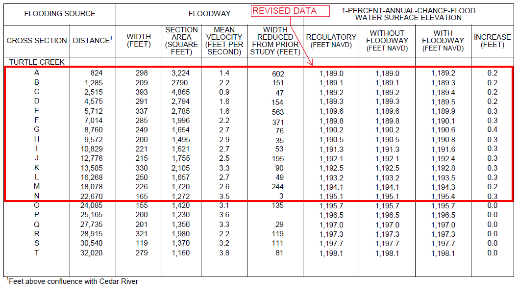
Panel 188D Cedar River & Turtle Creek, Southerly Reach
Panel 186D Cedar River, Center Reach
Panel 187D Cedar River, East Side Lake & Dobbins Creek
Panel 179D Cedar River, Northerly Reach & Wolf Creek
Panel 191D Dobbins Creek, No. & So. Branch, Nature Center
Panel 183D Dobbins Creek, North of City Limits
Panel 175D Turtle Creek, North of City Limits
Panel 167D Turtle Creek, Upper Reach
Panel 189D Two Creeks Reach, SE Austin
Floodplain Maps 1988
1988 Flood Insurance Rate Map Index
1988 SW Austin Flood Insurance Rate Map
1988 NE Austin Flood Insurance Rate Map


| Facts – City of Austin | |
| Population | 23,500 |
| County Seat | Mower County |
| Economic Basis | Agriculture, Food Industry |
| Major Employees | Hormel Foods, Inc Weyerhauser Austin Medical Center (Mayo) |
Where is all the water coming from?
To understand flooding in Austin you have to have general information regarding the watershed and the streams that impact the community.
Austin is the confluence of three different streams that make up the upper cedar river watershed.
- Cedar river
- Turtle creek
- Dobbins creek
[Not a valid template]
Flood history
- Five highest floods have occurred since 1978
- Flood events now occur in summer vs. Spring runoff
- Land use has become more developed thus greater impacts
- City of Austin has acquired 250 residential homes as part of our flood mitigation program
- With increased flooding levels, the impacts on our commercial/industrial properties have increased
Documented
Ten Highest Known Floods In Order Of Flow Magnitude
Cedar River At Austin, Mn
| DATE OF FLOOD | GAUGE HEIGHT (FT.) | MAXIMUM DISCHARGE (c.f.s.) |
|---|---|---|
| September 15, 2004 | 25.00 | 20,000 |
| July 10, 2000 | 22.90 | 15,500 |
| July 17, 1978 | 20.35 | 12,400 |
| August 15, 1993 | 19.43 | 10,800 |
| July 7, 1978 | 18.14 | 10,200 |
| March 29, 1962 | 17.18 | 9,530 |
| March 1, 1965 | 18.87 | 9,400 |
| March 26, 1950 | 17.81 | 8,800 |
| July 2, 1983 | 17.01 | 8,690 |
| April 6, 1966 | 16.21 | 16.21 |
Studies
- 1969 Corp. Of Engineers Study
- 1979 Corp. Of Engineers Study
- 1979 Flood Insurance Study
- 2001 FEMA Property Acquisition Study
- 2002 Corp. Of Engineers Study
- 2002 City Of Austin Hazard Mitigation Plan
- 2004 FEMA Post Event Mitigation Study
- 2005 City Of Austin North Main Study
Project
North Main Structural Mitigation
Study
City of Austin authorized a Mitigation Study to look at options to protect the North Main area.
Study cost approximately $90,000 which was funded with local dollars.
Project Scope
Project scope was to evaluate the feasibility and determine the costs to structurally protect the property along and adjacent to North Main.
Project Need
Property in this area has been significantly impacted by more severe and more frequent flooding events.
This project would protect the following:
- Hormel Foods Inc. Flagship Plant
- Employs 1,550 people
- Processes 19,000 hogs/day
- Plant had to be shut down during the 2004 flood
- Discharges 2.1 MGD wastewater
- Business interruption, $630,000/day
- Value to the agricultural community, $3,000,000/day
- Quality Pork Processors
- Employs 1,400 people
- Hormel Corporate Office South
- Employs 200 people
- Spam Museum
- 100,000 visitors/year
- Mayo Medical Center
- 6,000 Patient visits
- -Employs 900 people
- -Infrastructure of the Medical Center was threatened
- Numerous Commercial Businesses-Suffered severe financial losses
- Suffered severe financial losses
Project Benefit
- Provide flood protection to developed commercial and industrial property
- Grow industrial job base
- Hormel Foods Corp
- Provide stability to existing industrial and commercial businesses
Proposed Project Cost
- Total Cost $10,500,000
- Twelve Phases of Work
- Property Acquisition
- Structural Walls and Berm
Community Goal
The ultimate goal for the City of Austin is to remove or protect all structures in the flood plain. We are not there yet, but with continued efforts, flood damages to the community have been and can be significantly reduced.
By spending time and energy toward flood mitigation today, we can lessen the costs of disasters to our community tomorrow.
National Flood Insurance Program
Complete Guide to Flood Safety and Preparedness
NFIP Telephone Numbers
| Number | Service |
|---|---|
| 800-638-6620 | Direct Business |
| 800-720-1093 | Agent Information |
| 800-427-4661 | General Information |
| 800-611-6125 | Lender Information |
| 800-427-5593 | TDD |
| 800-336-2627 | FEMA Map Assistance Center(Information about flood hazard maps and map changes) |
| 800-358-9616 | FEMA Map Service Center(Order flood maps and FIS studies, Flood insurance Manual, and Community Status Book) |
| 800-480-2520 | FEMA Distribution Center |
| 800-497-6378 FAX | (Order free NFIP forms and public awareness materials) |
Regional Office Telephone Numbers
| Region | FEMA | NFIP Bureau & Statistical Agent |
|---|---|---|
| Region V | 312-408-5500 | 708-326-3072 |
North Main Flood Mitigation Project Summary, 2006 to 2020


North Main
Flood Mitigation
Structural Wall Options
- Review Design
- Structural/Berm
- Wall Options
- Solid Wall
- Solid Wall/Road Raise
- Invisible Wall
- Invisible Wall/Road Raise
- Wall Issues
- Cost
- Drainage
- Public Safety
- Flood Response Time
- Appearance
- Reliability/Life Expectancy
Cost:
In reviewing the options provided, the least expensive is the solid wall and the most expensive is the invisible wall with the road raise. The estimated cost difference between the solid wall and the invisible wall is approximately $500,000.
Other design considerations would include raising the road which has the potential of adding an additional cost of $250,000.
Numerous portions of the road will be impacted regardless of the method of construction.
Drainage:
The proposed project creates certain drainage issues that need to be addressed and include the following:
- All storm sewer outlets have two closures included which prevent water from backing up on the dry side of the berm during flood events
- Storm sewer lift station to pump the storm sewers in the event of a rainfall during a flood event
- Storm sewer drainage system on the dry side of the wall to prevent soil saturation during periods of flooding
- Storm sewer drainage system for road raise to accommodate drainage from private property
Public Safety:
The option of the solid wall creates certain public safety issues. The area between the wall and the Mill Pond is blocked from view from Main Street. This creates potential safety issues in the area adjacent to the Mill Pond. The invisible wall allows for the Mill Pond area to be visually accessible from Main Street.
Flood Response Time:
In reviewing the options available, the invisible wall does require a response by the City to install the planks for potential flooding events versus the solid wall design. For comparison purposes, the invisible wall with the road raise provides for flood protection approximately 12” higher than the flood of record (2004). The invisible wall would provide protection to a greater elevation and based on previous flood events, this installation is feasible.
Appearance:
In all options, the proposed wall is decorative in nature. In order to provide the level of protection required, the height of the wall becomes very imposing and has a significant impact on the North Main area. (Specifically the Mill Pond area) The City of Austin has made significant efforts for improvements to the Main Street corridor and the solid wall option has the potential to detract from the efforts made.
Reliability/Life Expectancy:
In all cases, there is a solid wall option to a protection level equal to the 2004 flood. This provides a safety level and response time that would allow the invisible wall to be feasible. If the invisible wall option would be chosen, an Action Plan would have to be developed that would provide for annual drills that would include installation.
Recommendation:
After much consideration and analysis of the options, it is my recommendation that the invisible wall with the road raise be approved. The basis for this recommendation is as follows:
Cost:
- Funding – The Local Option Sales Tax continues to exceed all projections
- Cost Sharing – All of the options are eligible based on the grant options
- Drainage Issues – All options have unique drainage challenges
- Additional costs represent less than 10% of the project cost for Phases 3-7
- If matching funds are received, City’s additional cost would be covered by 4 months of Local Option Sales Tax
Public Safety:
The invisible wall with the road raise eliminates many of the concerns from a public safety standpoint expressed by the Police and Fire Departments. These concerns include: access, visibility, and safety.
Flood Response Time:
All options provide a solid wall due to height exceeding the 2004 flood of record. This would provide the City the necessary time to install additional flood planking if needed.
Appearance:
Graffiti – The solid wall and lack of visibility on the Mill Pond side will be more conducive to graffiti.
The City has committed itself to the preservation and improvements of Main Street and Downtown. I think if the solid wall option was chosen that this would be a deterrent to the Downtown and Mill Pond area. Areas of improvements and growth in the Main Street area include:
- Library
- Downtown Revitalization
- Justice Center – Long term planning that would allow for Health & Human Services to relocate to Downtown
- Expansion plans of APC
- Hormel Corporate Office South
The investment in the Main Street and Downtown areas by both the public and private sectors are in the millions of dollars and through proper planning and infrastructure development this area will continue to be a strong economic base and cultural center for the City of Austin.
As the Council moves forward with this important decision, it will have significant impacts on how this area is currently used and the long range development plans that allow business and industry to interact with one of the community’s most significant recreational areas.
If you have any questions, please let me know.
- Before and After Images
- Site Acquisitions
- North Main Flood Mitigation Project
- Turtle Creek Flood Mitigation Project
- Wastewater Treatment Plant Levee Project
- Funding Sources
- Local Option Sales Tax
- State Flood Hazard Mitigation Program
- State DEED & Bonding grants
- Federal FEMA & EDA grants
- Recognition of Pat Lynch, MnDNR
- Floodplain Hydrologist
- Flood Hazard Mitigation Grant Program Manager